About SW Maps - GIS & Data Collector
SW Maps is a free GIS and mobile mapping app for collecting, presenting and sharing geographic information. Whether you are conducting a full scale GNSS survey with high precision instruments, need to collect large amount...
SW Maps is a free GIS and mobile mapping app for collecting, presenting and sharing geographic information.
Whether you are conducting a full scale GNSS survey with high precision instruments, need to collect large amount of location based data using nothing but your phone, or just need to view a few shapefiles with labels over a background map on the go, SW Maps has it all covered.
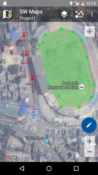
Record points, lines, polygons and even photos and have them displayed over your choice of background map, and attach custom attribute data to any feature. Attribute types include text, numbers, an option from a predefined set of choices, photos, audio clips and videos.
Conduct high accuracy GPS surveys using external RTK capable receivers over Bluetooth or USB Serial.
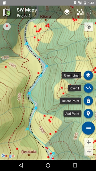
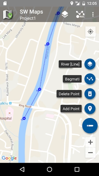
Draw features on the map by adding markers, and measure distance and area.
Reuse the layers and attributes of a previous project for another survey, or create templates and share them with other users.
Share the collected data with other users as Geopackages, KMZ or shapefiles, or export them to your device storage. Also share and export recorded data as Spreadsheets (XLS/ODS) or CSV files.
Features
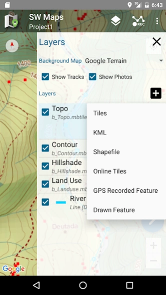
-Online Base maps: Google Maps or Open Street Map
-Support for multiple mbtiles and KML overlays
-Shapefile layers, with attribute categorized styling. View shapefiles in any coordinate system supported by the PROJ.4 library.
-Add multiple online WMTS, TMS, XYZ or WMS layers and cache tiles for offline use.
-Connect to external RTK GPS receivers through Bluetooth or USB Serial for high accuracy surveying using RTK. Also record data from external receiver for post processing.
-Define multiple number of feature layers, each with a set of custom attributes
Feature Types: Point, Line, Polygon
Attribute Types:Text, Numeric, Drop down Options, Photos, Audio, Video
Save as Template for re-use or sharing
-Record GPS tracks, with distance measurement
-Draw features on map and export as KMZ, Shapefiles, GeoJSON or GeoPackages.
-Label features based on attribute values.
-Import feature layers from templates or existing projects.
-Share or export collected data as KMZ (with embedded photographs) , shapefiles, GeoJSON, Geopackage (GPKG), XLS/ODS spreadsheets or csv files.
-Share templates or projects with other users
-Stake out points and lines on the ground using high accuracy GNSS receivers.
To load MBTiles, KML, shapefiles, GeoJSON and GeoPackage from external SD card, create the following folders in the SD card root and copy files to the relevant folders.
SW_Maps/Maps/mbtiles
SW_Maps/Maps/kml
SW_Maps/Maps/shapefiles
SW_Maps/Maps/geojson
SW_Maps/Maps/geopackage
For Android 11 users, the SW Maps folder can be found in Android/data/np.com.softwel.swmaps/files.
This product is made in Nepal and is FREE (no Ads). If you find this useful, please let your friends know that you have used a product from Nepal. Spare sometime to visit this wonderful country and know the Nepali people.
Previous Versions
Here you can find the changelog of SW Maps - GIS & Data Collector since it was posted on our website on 2016-12-29 21:02:47.
The latest version is 2.10.0.0 and it was updated on 2024-04-01 17:14:06. See below the changes in each version.
SW Maps - GIS & Data Collector version 2.10.0.0
Updated At: 2024-02-29
Changes: New "Checklist" attribute type for selecting multiple values from a list.
Export DOP and number of GNSS satellites in spreadsheet and CSV exports.
Fixed display of point elevations for drawn layers.
SW Maps - GIS & Data Collector version 2.9.5.6
Updated At: 2024-02-29
Changes: Added NAVIC (IRNSS) NMEA decoding for skyplot
Bug fix for polygon shapefile rendering
Added Mettatec X5 instrument profile
SW Maps - GIS & Data Collector version 2.9.5.5
Updated At: 2023-12-19
Changes: BLE and Geoid File Improvements
SW Maps - GIS & Data Collector version 2.9.5.4
Updated At: 2023-10-10
Changes: Fix for Android 14 Bluetooth LE GNSS connection
SW Maps - GIS & Data Collector version 2.9.5.2
Updated At: 2023-09-16
Changes: Added point and line stakeout tool. You can now use SW Maps to easily locate your points and lines on the ground.
SW Maps - GIS & Data Collector version 2.9.5.1
Updated At: 2023-08-20
Changes: Added ArduSimple BLE Bridge instrument
Track recording required accuracy can now be set to 1m
NTRIP support for Septentrio receivers
Measurement tools fix for drawing mode
Export fix quality, speed and bearing and accuracy for drawn layers if point is collected using GNSS
SW Maps - GIS & Data Collector version 2.9.4.1
Updated At: 2023-05-15
Changes: Record and display bearing for photo points
SW Maps - GIS & Data Collector version 2.9.2.2
Updated At: 2023-02-01
Changes: Fixed some external tile layers not loading
SW Maps - GIS & Data Collector version 2.8.2.2
Updated At: 2022-04-07
Changes: Mock Location Provider: You can now set SW Maps as a mock location provider in the developer options. This lets you use SW Maps Bluetooth/USB GNSS receivers as a location source for other apps.
Fix for location not working on Android 11 and 12.
SW Maps - GIS & Data Collector version 2.8.1.4
Updated At: 2021-08-19
Changes: Improvements to Android 11 support. Data files are now stored in the app-specific media directory in Android/media. The current SW Maps directory is now shown in the app settings. The add layer dialogs also show the layer folder path.
You can now load Geoid files in gtx format. Copy the gtx files to the SW_Maps/Geoid folder, and select the active geoid in app settings. Orthometric height is recorded and exported for all points.
Many bug fixes
Disclaimer
Official Google Play Link
We do not host SW Maps - GIS & Data Collector on our servers. We did not scan it for viruses, adware, spyware or other type of malware. This app is hosted by Google and passed their terms and conditions to be listed there. We recommend caution when installing it.
The Google Play link for SW Maps - GIS & Data Collector is provided to you by apps112.com without any warranties, representations or guarantees of any kind, so access it at your own risk.
If you have questions regarding this particular app contact the publisher directly. For questions about the functionalities of apps112.com contact us.